Barns of Mackinac County, Michigan
135 Barns plus a few "extras"
R.V. ("Dick") Dietrich
Professor emeritus C.M.U.
|
Appendix.
Locations: State outline map, County
map with township borders, and List, by township, of the barns and "extras" of which photographs are included in this album. |
|
|
|
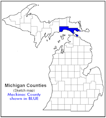
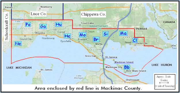
Sketch map. Locations of townships within Mackinac County. The black and white dashed lines indicate the approximate boundaries between adjacent townships. The two-letter indicators on this map are used to designate the townships where the barns are located in both the captions of the photographs and on the following list. West to east the correlations of the two-letter indicators and full names are: Ne-Newton, Po-Portage, Ga-Garfield, Hu-Hudson, He-Hendricks, Mo-Moran, Br-Brevort, Si-St. Ignace, Ma-Marquette, Bb-Bois Blanc, and Cl-Clark. Two additional indicators, MIC and SIC, are similarly utilized for the included barns that are on Mackinac Island and in St. Ignace, respectively. |
| List of photographed barns and"extras" by Townships. These locations are plotted by number on the latest
Plat Book ... (Mackinac County ..., 2009). The page number in that book is given
directly after the number given each structure on this list. That book and
additional photos on CD are on file in the XXnameXX Library,
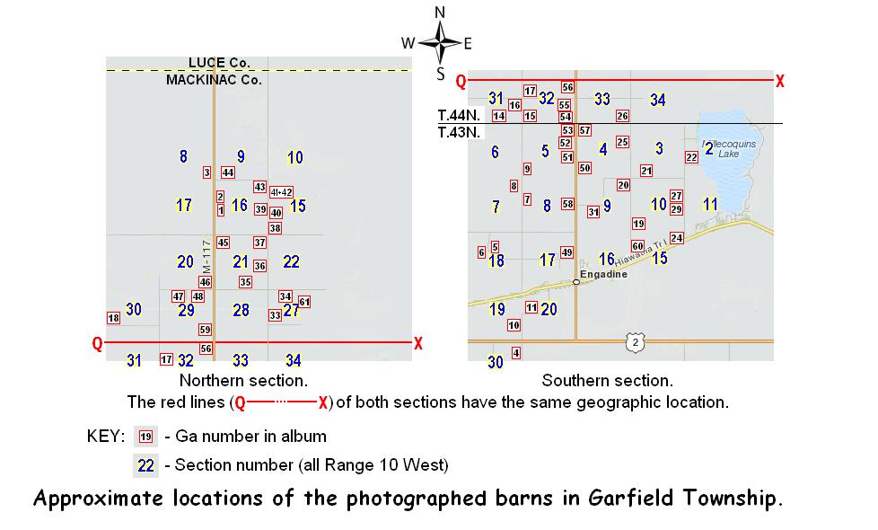
XXplaceXX, Michigan. Bois Blanc Township _____ Bb1. (p. 44=extra #1) north of Lime Kiln Point Rd.; SEĽ sec.17* T.39N.-R. 2W. *see text re section designation. Brevort Township [[7 + 4 extras]] Br1. (p. 36=extra #2) east of H57; SWĽ sec.2, T.41N.-R.5W. Br2. (p. 36) west of H57; NWĽ sec.2, T.41N.-R.5W. Br3. (p. 37) south of H57; NWĽ sec.5, T.41N.-R.4W. Br4. (p. 31=extra #3)) north of H57; NWĽ sec.32, T.42N.-R.4W. Br5. (p. 31) north of Dukes Rd.; NEĽ sec.31, T.42N.-R.4W. Br6. (p. 31) south of Dukes Rd.; SEĽ sec.31, T.42N.-R.4W. Br7. (p. 37=extra #4) north of Rte. 129; SEĽ sec.4, T.41N.-R.4W. Br9. (p. 30) west of Black Point Rd.; SEĽ sec.25, T.42N.-R.5W. Br10. (p. 37) east of Langdon Rd.; NEĽ sec.5, T.41N.-R.4W. Br11. (p. 31) east of Martin Rd.; NWĽ sec.33, T.42N.-R.4W. Br12. (p. 30=extra #5) west of Black Point Rd.; SWĽ sec.36, T.42N.-R.5W. Clark Township [[9 + 1 extra]] Cl1. (p. 34) north of Nye Rd.; SWĽ sec.21, T.42N.-R.1W. Cl2. (p. 34=extra #6) south of State St.; SWĽ sec.25, T.42N.-R.1W. Cl3. (p. 35) east of Meridian St.; NWĽ sec.31, T.42N.-R.1E. Cl4. (p. 35) north of Norquist Rd.; SEĽ sec.18, T.42N.-R.1E. Cl5. (p. 35) north of Swede Rd.; SEĽ sec.7, T.42N.-R.1E. Cl6. (p. 35) west of Winberg Rd.; SWĽ sec.9, T.42N.-R.1E. Cl7. (p. 35) north of Swede Rd.; SWĽ sec.9, T.42N.-R.1E. Cl8. (p. 35) south of Swede Rd.; NEĽ sec.15, T.42N.-R.1E. Cl9. (p. 35) east of Rte. 129; SWĽ sec.18, T.42N.-R.1E. Cl11. (p. 35) south of 30 Mile Rd.; NEĽ sec.1, T.42N.-R.1E. (= #105, p.45 in Pickford..., 2004) Garfield Township [[50(+3) + 4 extras]] The following sketch map shows the locations of the barns shown by photographs in this album. It is given, along with the list of locations, because the numbers of the photographs, and thus of the locations, do not have any logical relationship to the roads and geography. They are, instead, in the order in which the photographs were taken, and that depended upon such things such as light conditions and traffic. It is hoped that the map will aid anyone going through the area who might want to correlate their travel plans and routes they take to see the photographed barns. |
|
|
| Ga1.
(p. 11) east of Rte. 117; SWĽ sec.16,
T.44N.-R.10W. Ga2. (p. 11) east of Rte. 117; NWĽ sec.16, T.44N.-R.10W. Ga3. (p. 11) west of Rte. 117; SEĽ sec.8, T.44N.-R.10W. Ga4. (p. 17)west of Price Rd.; NEĽ sec.30, T.43N.-R.10W. Ga5. (p. 17)south of Linck Rd.; NWĽ sec.18, T.43N.-R.10W. Ga6. (p. 17)south of Linck Rd.; NEĽ sec.18, T.43N.-R.10W. Ga7. (p. 17)east of Pleasant Ave.; NWĽ sec.8, T.43N.-R.10W. Ga8. (p. 17)west of Pleasant Ave.; NEĽ sec.7, T.43N.-R.10W. Ga9. (p. 17)east of Pleasant Ave.; SWĽ sec.5, T.43N.-R.10W. Ga10. (p. 17)west of Price Rd.; SEĽ sec.19, T.43N.-R.10W. Ga11. (p. 17)north of Price Rd.; NWĽ sec.20, T.43N.-R.10W. Ga12. (p. 17=extra #7)north of Linck Rd.; SEĽ sec.8, T.43N.-R.10W. Ga13. (p. 17=extra #8)west of Pleasant Ave.; SEĽ sec.6, T.43N.-R.10W. Ga14. (p. 11)north of Patzen Rd.; SWĽ sec.31, T.44N.-R.10W. Ga15. (p. 11)east of Pleasant Ave.; SWĽ sec.32, T.44N.-R.10W. Ga16. (p. 11=extra #9)west of Pleasant Ave.; NEĽ sec.31, T.44N.-R.10W. Ga17. (p. 11)east of Pleasant Ave.; NWĽ sec.32, T.44N.-R.10W. Ga18. (p. 11)north of Kovar Rd.; NWĽ sec.30, T.44N.-R.10W. Ga19. (p. 17)east of Krause Rd.; SWĽ sec.10, T.43N.-R.10W. Ga20. (p. 17)south of Raski Rd.; NEĽ sec.9, T.43N.-R.10W. Ga21. (p. 17)north of Raski Rd.; SWĽ sec.3, T.43N.-R.10W. Ga22. (p. 17)east of Indian Trl.; SWĽ sec.2, T.43N.-R.10W. Ga24. (p. 17)north of Hiawatha Trl. [Rte. H40]; NEĽ sec.15, T.43N.-R.10W. Ga25. (p. 17)west of Krause Rd.; NEĽ sec.4, T.43N.-R.10W. Ga26. (p. 11) west of Krause Rd.; SEĽ sec.33, T.44N.-R.10W. Ga27. (p. 17) west of Indian Trl.; NEĽ sec.10, T.43N.-R.10W. Ga29. (p. 17) west of Indian Trl.; SEĽ sec.10, T.43N.-R.10W. Ga30. (p. 17) southeast of Raski Rd.; SEĽ sec.9, T.43N.-R.10W. Ga31. (p. 17) south of Raski Rd.; SWĽ sec.9, T.43N.-R.10W. Ga32. (p. 11=extra #10) west of Krause Rd.; NEĽ sec.33, T.44N.-R.10W. Ga33. (p. 11) east of Krause Rd.; NWĽ sec.27, T.44N.-R.10W. Ga34. (p. 11) south of McKelvey Rd.; NWĽ sec.27, T.44N.-R.10W. Ga35. (p. 11) north of McKelvey Rd.; SWĽ sec.21, T.44N.-R.10W. Ga36. (p. 11) west of Krause Rd.; SWĽ sec.21, T.44N.-R.10W. Ga37. (p. 11) west of Krause Rd.; NWĽ sec.21, T.44N.-R.10W. Ga38. (p. 11) north of Sandtown Rd.; SWĽ sec.15, T.44N.-R.10W. Ga39. (p. 11) west of Krause Rd.; SEĽ sec.16, T.44N.-R.10W. Ga40. (p. 11) east of Krause Rd.; SWĽ sec.15, T.44N.-R.10W. Ga41. (p. 11) east of Krause Rd.; NWĽ sec.15, T.44N.-R.10W. Ga42. (p. 11) east of Krause Rd.; NWĽ sec.15, T.44N.-R.10W. Ga43. (p. 11) west of Krause Rd.; NWĽ sec.16, T.44N.-R.10W. Ga44. (p. 11) north of Brown Rd.; SEĽ sec.9, T.44N.-R.10W. Ga45. (p. 11) east of Rte. 117; NWĽ sec.21, T.44N.-R.10W. Ga46. (p. 11) west of Rte 117; SEĽ sec.20, T.44N.-R.10W. Ga47. (p. 11) south of McKelvey Rd.; NWĽ sec.29, T.44N.-R.10W. Ga48. (p. 11) south of McKelvey Rd.; NEĽ sec.29, T.44N.-R.10W. Ga49. (p. 17) west of Rte.117; NEĽ sec.17, T.43N.-R.10W. Ga50. (p. 17) east of Rte.117; SWĽ sec.4, T.43N.-R.10W. Ga51. (p. 17) west of Rte.117; SEĽ sec.5, T.43N.-R.10W. Ga52. (p. 17) west of Rte.117; NEĽ sec.5, T.43N.-R.10W. Ga53. (p. 17) west of Rte.117; NEĽ sec.5, T.43N.-R.10W. Ga54. (p. 11) west of Rte.117; SEĽ sec.32, T.44N.-R.10W. Ga55. (p. 11) west of Rte.117; SEĽ sec.32, T.44N.-R.10W. Ga56. (p. 11) west of Rte. 117; NEĽ sec.32, T.44N.-R.10W. Ga57. (p. 17) east of Rte. 117; NWĽ sec.4, T.43N.-R.10W. Ga58. (p. 17) west of Rte. 117; NEĽ sec.8, T.43N.-R.10W Ga59. (p. 11) west of Rte. 117; SWĽ sec.29, T.44N.-R.10W. Ga60. (p. 17) north of Hiawatha Trl.; NWĽ sec.15, T.43N.-R.10W. Ga61. (p. 11) northeast of Warner Rd.; NEĽ sec.27, T.44N.-R.10W. Hendricks Township [[1 + 1 extra]] He1. (p. 20=extra #11) north of Epoufette Bay Rd.; SWĽ sec.3, T.42N.-R.7W. He3. (p. 20) south end of Kenyon Rd.; NEĽ sec.8, T.42N.-R.7W. Hudson Township [[0 + 1 extra]] Hu1. (p. 19=extra #12) west of Black River Rd.; SEĽ sec.19, T.43N.-R.8W. Marquette Township [[24 + 2 extras]] Ma1. (p. 25=extra #13) east of Simmons Rd.; SWĽ sec.30, T.43N.-R.2W. Ma2. (p. 33) south of St. Ignace Rd.; NEĽ sec.9, T.42N.-R.2W. Ma3. (p. 33=extra #14) north of St. Ignace Rd.; SEĽ sec.9, T.42N.-R.2W. Ma4. (p. 26) north of Taylor Rd.; SEĽ sec.9, T.43N.-R.1W Ma5. (p. 26) south of Taylor Rd.; NWĽ sec.14, T.43N.-R.1W Ma6. (p. 26) west of Rte. 48/129; NEĽ sec.24, T.43N.-R.1W Ma7. (p. 26) west of Rte. 48/129; NEĽ sec.25, T.43N.-R.1W Ma8. (p. 26) south of Rockview Rd.; NWĽ sec.36, T.43N.-R.1W. NOTE: A black and white photograph and information about each of the following barns is in Pickford..., 2004. The photos shown in this album provide a different view, taken in 2011, of each of these barns. The numbers following the MaP- prefix indicate the order in which these photographs were taken, which also provides a good order to view the barns. The information in parentheses at the end of each barn location corresponds to the number and page where information about the barn is in the Pickford ... (2004) publication. It seems noteworthy that five additional barns, no longer present, are also shown in the Mackinac County section recorded in Pickford ... (ibid.) MaP-1. (p. 26) south of Townline Rd.; NWĽ sec.1, T.43N.-R.1W. (= #56, p.28) MaP-2. (p. 26) south of Townline Rd.; NEĽ sec.6, T.43N.-R.2W. (= #24, p.16) MaP-3. (p. 26) east of 5 Mile Rd.; NEĽ sec.6, T.43N.-R.2W. (= #26, p.16) MaP-4. (p. 26) south of Townline Rd.; NWĽ sec.5, T.43N.-R.2W. (= #32, p.19) MaP-5. (p. 26) south of Townline Rd.; NWĽ sec.5, T.43N.-R.1W. (= #34, p.20) MaP-6. (p. 26) south of Townline Rd.; NWĽ sec.2, T.43N.-R.1W. (= #54, p.27) MaP-7. (p. 26) north of Blair Rd.; SEĽ sec.1, T.43N.-R.1W. (= #58, p.28) MaP-8. (p. 26) south of Blair Rd.; NEĽ sec.12, T.43N.-R.1W. (= #59, p.29) MaP-9. (p. 26) south of Blair Rd.; NEĽ sec.12, T.43N.-R.1W. (= #61, p.29) MaP-10. (p. 26) west of 1 Mile Rd.; SWĽ sec.2, T.43N.-R.1W. (= #62, p.30) MaP-11. (p. 26) north of Blair Rd.; SWĽ sec.2, T.43N.-R.1W. (= #64, p.31) MaP-12. (p. 26) north of Blair Rd.; SWĽ sec.2, T.43N.-R.1W. (= #65, p.31) MaP-13. (p. 26) north of Bla;ir Rd.; SEĽ sec.3, T.43N.-R.1W. (= #67, p.32) MaP-14. (p. 26) north of Blair Rd.; SEĽ sec.4, T.43N.-R.1W. (= #68, p.32) MaP-15. (p. 26) south Taylor Rd.; NEĽ sec.14, T.43N.-R.1W. (= #69, p.33) MaP-16. (p. 26) south Taylor Rd.; NEĽ sec.13, T.43N.-R.1W. (= #71, p.34) MaP-17. (p. 26) west of Rte. 129/48; SEĽ sec.12, T.43N.-R.1W. (= #72, p.34) MaP-18. (p. 26) west of Rte. 129/48; NEĽ sec.12, T.43N.-R.1W. (= #73, p.35) MaP-19. (p. 26) south of Blair Rd.; NEĽ sec.12, T.43N.-R.1W. (= #57, p.29 Moran Township [[5 + 0 extras]] Mo1. (p. 41) northwest of New Portage Rd.; NWĽ sec.14, T.40N.-R.3W. Mo2. (p. 41) south of Old Portage Rd.; NWĽ sec.1, T.40N.-R.3W. Mo3. (p. 41) northwest of Martin Lake Rd.; NWĽ sec.9, T.40N.-R.3W. Mo4. (p. 22) north of Lovegrove Rd.; SEĽ sec.4, T.43N.-R.5W. Mo6. (p. 41) east of Gros Cap Rd.; NWĽ sec.8, T.40N.-R.4W. Newton Township [[9 + 2 extras]] Ne1. (p. 16) west of Greenwald Rd.; NEĽ sec.25, T.43N.-R.11W. Ne2. (p. 16) south of Rte. 2; NEĽ sec.25, T.43N.-R.11W. Ne3. (p. 15=extra #16) north of Brotherton Rd.; SWĽ sec.2, T.43N.-R.12W. Ne4. (p. 16) north of Clark Rd.; SEĽ sec.28, T.43N.-R.11W. Ne5. (p. 16) east of Brawley Rd.; NWĽ sec.26, T.43N.-R.11W. Ne6. (p. 28) west of S. Gould City Rd.; SWĽ sec.28, T.42N.-R.11W. Ne7. (p. 28) west of S. Gould City Rd.; SWĽ sec.28, T.42N.-R.11W. Ne8. (p. 16) south of Main St., Gould City; SWĽ sec.28, T.43N.-R.11W. Ne9. (p. 16) north of Hiawatha Trl.[=H40]; NEĽ sec.23, T.43N.-R.11W. Ne10. (p. 16=extra #15) north of Hiawatha Trl.=H40]; NEĽ sec.23 T.43N.-R.11W. Ne11. (p. 16) north of Clark Rd.; SEĽ sec.28, T.43N.-R.11W. Portage Township [[5 + 1 extra]] Po1. (p. 10) east of Rte. H-33, SWĽ sec 30, T.43N.-R.11W. Po2. (p. 9) east of County Line Rd., SWĽ sec.7, T.44N.-R.12W. Po3. (p. 9) south of Ketola Rd., NEĽ sec.7, T.44N.-R.12W. Po4. (p. 9) east of County Line Rd., NWĽ sec 7, T.44N.-R.12W. Po5. (p. 9=extra #17) east of McGahn Rd., SEĽ sec 17, T.44N.-R.12W. Po7. (p. 10) north of Sandtown Rd., SWĽ sec.17, T.44N.-R.11W. St. Ignace Township [[4 + 0 extras] Si1. (p. 32) north of Charles Moran Rd.; SEĽ sec.30, T.41N.-R.3W. Si2. (p. 32) west of Pine River Rd.(south of Rte. 134); NEĽ sec.10, T.42N.-R.3W. Si3. (p. 37) south of Rte. 129; NEĽ sec.11, T.41N.-R.3W. Si4. (p. 32) north of St. Ignace Rd.; SEĽ sec.1, T.42N.-R.3W. Mackinac Island, City [[7 (+2) + 0 extras]] MIC1. (p. 42)East of Market St.; SWĽ sec.14, T.40N. R.3W. MIC3. (p. 42)Southwest of Cadotte St.; NEĽ sec.15, T.40N. R.3W. MIC6. (p. 42)North of Algonquin Rd.; SWĽ sec.10, T.40N. R.3W. MIC7. (p. 42)North of Algonquin Rd.; SWĽ sec.10, T.40N. R.3W. MIC8. (p. 42)North of Algonquin Rd.; SWĽ sec.10, T.40N. R.3W. MIC12. (p. 42)North of Park Rd.; SWĽ sec.3 , T.40N. R.3W. MIC13. (p. 42)East of Carriage Rd.; SEĽ sec.10, T.40N. R.3W. St. Ignace, City [[3 + 0 extras]] SIC1. (p. 41& 49) north of Ferry Lane; SWĽ sec.17, T.40N.-R.3W. SIC2. (p. 41& 49) south of Burdette St.; SWĽ sec.17, T.40N.-R.3W. SIC3. (p. 41& 48) north of Portage St.; SWĽ sec.7, T.40N.-R.3W. SIC4. (p. 41& 48=extra #18)) south of Prospect St.; NWĽ sec.18, T.40N.-R.3W. |
References. Cited, general publications and web sites of possible interest: (The general publications and web sites that are listed are among several that were reviewed while working on this project. Those included here are likely to be of interest to anyone who as looked at this album.) Cited: Dietrich, R.V. 2008. Isabella's stones: Fieldstone buildings, walls, landscape accents and other uses. http://condor.cmich,edu/u?/p1610-01coll1,3225. 176p. . . . . . . . . . . . 2010. Straits' stones: A picture album (subtitle: Fieldstones -- bulidings and other uses). Vol. I. Mackinac County. (Cite either my web site or CONDOR, depending upon where this document is at end.) Engadine Centennial: 1894-1994. 1994. Engadine MI:Centennial Committee. 324p. Hill, G.L. 1918. The enchanted barn. New York:Grosset & Dunlap. 313p. Land atlas & plat book: Mackinac County, Michigan. 11th ed. n.d. (~1999). Rockford(IL):Rockford Map Publishers, Inc. 62p. Kiwanis Club (St. Ignace, Mich.). 1957. Before the bridge; a history and a directory of St. Ignace and nearby localities (commemorating the opening of the Mackinac Bridge). St. Ignace(MI):Kiwanis Club of St. Ignace, Mich., Inc. 270p. Mackinac County, Michigan Plat Book. 2009 [Belmond(IA)]:Farm & Home Publishers, Ltd. 72p. More Treasures found in the Limestone Barn. Life on Liberty Creek Farm. 9 December 2008, http://libertycreekfarm.blogspot.com/2008/12/more-treasures-found-in-limestone-barn.html (accessed 12 August 2011). Mozola, A.J. 1989. U.S. Public land survey grid in Dutro, J.T., Jr., R.V. Dietrich and R.M. Foose. AGI Data sheets for geology in the field, laboratory, and office (third edition). Sheet 5.1-5.2. [Alexandria(VA):American Geological Institute] Pickford Area Historical Sociey. 2004. Pickford patchwork: the fabric of a farming community: Barns. Pickford(MI):the Society. 70p. Trout Lake Women's Club. 1976. Tales & trails of Tro-La-Oz-Ken: a Bicentennial publication of the Trout Lake Women's Club. [Trout Lake(MI)]:the Club. 158p. Vosper, Jim. 2001. Island boyhood: A Memoir. Miwaukee(WI):Stone Beach Books. 118p. ~~&&~~
Noble,
A.G. and R.K. Cleek. 1995. The old barn book: A field guide
to North American barns and other
General publications:
Arthur, Eric and Dudley Whitney. 1972. The barn: A vanishing landmark in North Ameria. Greenwich(CT):New York Graphic Society, Ltd. 256p. This is a "coffee table" book and more! Ervin, Brenda. 2004. Barns of Michigan (2nd ed.). Swartz Creek(MI):Barn Door Pub. 190p. This publication has several additional publications listed on pages 170-174. Hartman, Lee. n.d. (1975-1988?) Michigan barns, our vanishing landmarks [subtitle: A wondrous assortment of Barns ...]. A Michigan Natural Resources Publication. 14p. This is a well illustrated summary about several aspects of barns. Ingells, Norris. 1995. That old barn: group works to preserve agricultural history. Lansing [MI] State Journal, Aug. 1, 1995 Johnson, Evelyn. 2007. Barns of Old Mission Peninsula and their stories (Revised edition). Traverse City(MI):Book Marketing Solutions. 214p. A "coffee table" book about the barns of the indicated area. Keithan, Mary. 1999. Michigan's heritage barns. East Lansing(MI):Michigan State University Press. 128p. A "coffee table" book of fine photographs with relatively short captions. One of the included barns (p. 41) is identified as in Mackinac County, but otherwise not located. I have been unable to identify it as one of the barns included in this album. Leffingwell, Randy. 2001. Barns. St. Paul(MN):Motoe Books International. 192p. A "coffee table" book of fine photographs with a few telling captions -- e.g., "Between technological advances and legal requirements, a number of barns became obsolete overnight ... Farming is a business and the cost of paying workers to put hay bales by hand into a barn ... instead of rolling the hay in plastic and leaving it in the field can mean the difference ... between showing a profit and suffering a loss." (p.188) -- and a more or less laboring text in many places. Lonski, Tina. 2008. Barn raising: Stories of a vanishing American legacy. Holt(MI):Essential Communications. 114p. National Trust for Historic Preservation. 2005("Copyright ... Revised). Barn again!, Barn preservation information handbook: A guide for individuals and organizations Denver(CO):National trust for historic preservation. 118p. This book should be at least scanned by anyone interested in or working on projects dealing with barns. farm structures (illustrations by M.M. Geib). New Brunswick(NJ):Rutgers University Press. 222p. This book is a fine source of information, with excellent illustrations, that pertain to the nomenclature widely applied to barns, secondary farm structures and even fencing. Pickvet, Kate, Mark Pickvet and Robin Rainwater. 2004. A pictorial history of barns and other farm structures in Michigan. Salem(MA):Higginson Book Co. 342p. People interested in barns should have this book as a ready reference -- both for the contents of its text and its photographs. The photographs, which are black and white, include several farm buildings (etc.) other than barns that are or once were in Michigan. For some readers, the fact that the locations of most of the barns etc. are only by county for the lower peninsula and noted only as in the "Upper Peninsula, Michigan" will be frustrating. Had more definitive locations been given, observers could, for example, see how the buildings have fared between the time those photographs were taken -- also not indicated, but all certainly before 2004 -- and when more recently viewed. Sloane, Eric. 1954. American barns and covered bridges. New York:Funk and Wagnalls. 112p. This book includes, among other things, fine "pen and ink?"sketches of tools used by the barn builders of the past. One particularly interesting illustration shows a " 'PERMANENT' fastening ... made by forcing a Square Peg into a Round Hole." (p.76) ................... 1967. An age of barns. New York:Funk and Wagnalls. 113p. [version read: 1985 reprint by Dodd, Mead & Company, New York] This book also includes some fine "pen and ink?" sketches, most of which depict buildings and parts thereof, as well as a text that is well worth reviewing. Sommer, R.L. 1997. The old barn book. New York: Barnes and Noble. 144p. .................. 2000. The ultimate book of historic barns. San Diego(CA):Thunder Bay Press. 256p. Two "coffee table" books. Stier, Steve. 2000. Michigan farm and farmstead survey. Jackson(MI): Jackson Printing Company, Inc. 32p. This well-illustrated booklet is provides guidelines for barn surveys. ~~&&~~
https://mibarn.net --- Michigan Barn Preservation Network (based in Mt. Pleasant, Michigan) n.d. http://michiganbarns.org/ --- Michigan Barn and Farmstead Survey (Michigan State University Extension/Michigan State University Museum) last updated September, 2009. http://www.barnalliance.org/ --- National Barn Alliance (National Barn Alliance), 2009. |